22 December 2008

My World Tuesday-The Maury River, Rockbridge County, Virginia

The Dam at Lexington, Virginia

Please check out That's My World where people from all over the world share pictures of their part of the world.

Sunday, the 21st I decided to head up the highway toward Lexington, Virginia. Lexington is located in Rockbridge County and is adjacent to Botetourt County where I live. I braved howling winds, snow flurries and temperatures in the high 20s to capture some shots around the area. It was absolutely beautiful out and well worth braving the cold. I will be posting photographs of my excursion in the weeks ahead.

As you travel north on Interstate 81 from Botetourt County you get a look at the Maury River as it passes under the interstate. The Maury River gathers its headwaters miles to the north beyond U.S. Highway 250 which snakes through the rugged mountains between the western Virginia towns of Churchville and Monterey.

Small mountain streams, many of which hold native brook trout join to form the Calfpasture River which merges with the Little Calfpasture River just west of Goshen Pass. There the Maury River is born. The water of the two major tributaries barely have time to mingle before the Maury enters the famous Goshen Pass and begins a turbulent run downstream as much as 20 feet in one 100 yard stretch of the river. Once through the Pass, the river drops into the valley, continuing toward Lexington at a fast pace. It maintains that rate of flow, except where man intervened, until it enters the James River at Glasgow.
Unlike most Virginia Rivers, the Maury is contained entirely within Rockbridge County. It deos not cross any county lines. While nature designed the Maury as a fast flowing stream from its headwaters to the confluence with the James, several dams have changed its personality. A pair of dams, an eight-foot one in Lexington (pictured here) and a 20-foot one near Buena Vista impound the fast water forming stretches of calm water behind them.
The Maury River is fairly short by most standards. From the confluence of the Calfpasture and the Little Calfpasture Rivers, it is approximately 30 miles to its confluence with the James River. Enroute it brushes the charming cities of Lexington and Buena Vista. While there is challenging whitewater such as Devil's Kitchen and other rapids too difficult for the novice to tackle, the river offers plenty of Class I and II water that the average canoeist or kayaker can handle. In addition to the fast water at Goshen Pass, there are the remains of Goose Neck Dam downstream from Buena Vista that require care. This is Class II+ water.
The names of rivers often raise questions from serious river lovers. How did the river get that name? Some times there is an explanation, some times none. There is, however, an explanation for this one. The Maury River was first called the North River of the James. It enters the James River from the north. But then came Matthew Fontaine Maury, a professor at Virginia Military Institute in the years following the Civil War during which he had served in the Confederate forces. In those postwar years he fell in love with Goshen Pass and requested that at his death his remains be carried through the pass and on to Richmond for burial. An honor guard of Virginia Military Institute Cadets carried out his wish. A monument in his hor now rests on the side of Virginia Primary Highway 39 where it passed through Goshen Pass. And the river was named for him.
Obviously the Maury River gets a lot of attention from whitewater canoeists and kayakers, primarily becuase of the Goshen Pass wild water. Most of this kind of river recreational use occurs during the colder months when the river is high. During the dry months of summer the river in this section is too low to canoe or even use a kayak. The only exception comes when heavy rainfall in the watershed of the river raise its level significantly, even if only for a day or so.

21 December 2008

Today's Flowers-Colorful Flowering Cabbage


Be sure to take time to click on the link below for more photos from bloggers participating in Today's Flowers.

Found this lovely festive entry when I was out and about in Lexington today braving the cold winds and frigid temperatures. Had a good time walking about town and capturing some great shots which I will share with you all in the weeks ahead. Hope you enjoy.

Family: Brassicaceae
Genus: Brassica
Species: oleracea var. acephala

Flowering Cabbage and Kale are ornamental versions of the cabbage and kale that we use as edible vegetables. They have been hybridized and selected for ornamental features including bright foliage colors and compact growth. Growing best in cool weather, the seeds are sown in the early summer and several month old plants are transplanted into the garden in the late summer or early fall. As the weather cools, the purple, pink or white colors of the leaves become quite pronounced. The plants can tolerate cold weather, and in mild winters can look attractive up until spring arrives.

The name “flowering” cabbage and kale is a misnomer since the ornamental parts of the plant we value are really just fancy leaves that superficially resemble the petals of flowers. The plants can and often will eventually produce real flowers if left in the garden. As biennials they only bloom after experiencing winter conditions after their first season of growth. Long stalks bearing small yellow flowers will develop when the weather warms in the spring. The flowers are not especially attractive and the foliage is usually quite ragged after surviving the winter. Most people remove the plants and deposit them in a compost pile long before they bloom.

The species to which flowering cabbage and kale belongs is truly fascinating. Wild Brassica oleracea is native to the coastal regions of Europe, from England to Italy, and still persists there today. The ancient Greeks and Romans grew it for food, but when it first was cultivated remains lost in history. The diversity of form within this species, that is the result of selection over the millennia by people, is almost unmatched in the plant world.

All of the following are members of Brassica oleracea:
Cabbage, Kale, Brussels Sprouts, Broccoli, Kohlrabi, and Cauliflower. As different as these plants are from each other, they are just variations of the same basic form. For example, a head of cabbage is really a large terminal bud at the end of a stem, while Brussels sprouts are really side or axillary buds on a stem without a large terminal bud. Recent DNA studies have confirmed the close relationship amongst these plants, and support the plant taxonomists who have classified all these types as varieties of the same species. There are some practical applications for this knowledge of plant taxonomy. If a family member will not even try eating brussels sprouts, but enjoys cabbage or another member of this group, you can tell them with an air of authority that they are really the same species. You might even try to convince someone that kohlrabi is just another type of broccoli.

16 December 2008

My World-The Red Tailed Hawk aka Buteo jamaicensis


We often have these beautiful birds of prey at the Airport. They love to snack on pigeons and other tidbits that roam and roost adjacent to the Airport perimeter. I have to admit that these are probably one of my favorite birds. Please check out That's My World where people from all over the world share pictures of their part of the world.

The Red-tailed Hawk (Buteo jamaicensis) is a medium-sized bird of prey, one of three species colloquially known in the United States as the "chickenhawk," though it rarely preys on chickens. It breeds throughout almost all North America from western Alaska and northern Canada to as far south as Panama and the West Indies, and is one of the most common buteos in North America. There are fourteen recognized subspecies, which vary in appearance and range. It is one of the largest members of the genus Buteo in North America, typically weighing from 690 to 1600 grams (1.5 to 3.5 pounds) and measuring 45–65 cm (18 to 26 in) in length, with a wingspan from 110 to 145 cm (43 to 57 in). The Red-tailed Hawk displays sexual dimorphism in size, as females are about 25% heavier than males.

A male Red-tailed Hawk may weigh from 690 to 1300 grams (1.5 to 3.5 pounds) and measure 45–56 cm (18 to 22 in), while a female can weigh between 900 and 2000 grams (2 and 4.4 pounds) and measure Body size, 18 to 26 in (45 to 65 cm); Wingspan,is about 3.8 to 4.3 (1.1 to 1.3 m) (20 to 26 in) in length. As is the case with many raptors the Red-tailed Hawk displays sexual dimorphism in size, as females are 25% larger than males. The wingspan is from 110 to 145 cm (43 to 57 in).

Red-tailed Hawk plumage can be variable, depending on the subspecies and the region. These color variations are morphs, and are not related to molting.

The western North American population, B. j. calurus, is the most variable subspecies and has three color morphs: light, dark, and intermediate or Rufus. The dark and intermediate morphs constitute 10–20% of the population.

Though the markings and hue vary, the basic appearance of the Red-tailed Hawk is consistent. The underbelly is lighter than the back and a dark brown band across the belly, formed by vertical streaks in feather patterning, is present in most color variations. The red tail, which gives this species its name, is uniformly brick-red above and pink below.The bill is short and dark, in the hooked shape characteristic of raptors. The cere, the legs, and the feet of the Red-tailed Hawk are all yellow.

Immature birds can be readily identified at close range by their yellowish irises. As the bird attains full maturity over the course of 3–4 years, the iris slowly darkens into a reddish-brown hue. In both the light and dark morphs, the tail of the immature Red-tailed Hawk are patterned with numerous darker bars.

In flight, this hawk soars with wings in a slight dihedral, flapping as little as possible to conserve energy. Active flight is slow and deliberate, with deep wing beats. In wind, it occasionally hovers on beating wings and remains stationary above the ground. When soaring or flapping its wings, it typically travels from 20 to 40 mph (64 km/h), but when diving may exceed 120 mph (190 km/h). When the Red-tailed Hawk walks, its steps are slow and awkward.

The Red-tailed Hawk is generally non-aggressive toward people and toward other birds. It is commonly harassed by crows, magpies, owls, other hawks, and even songbirds over territorial disputes, though it is generally not injured. When threatened by a human intruder, a Red-tailed Hawk will generally flee rather than defend its nest.

The cry of the Red-tailed Hawk is a two to three second hoarse, rasping scream, described as kree-eee-ar, which begins at a high pitch and slurs downward. This cry is often described as sounding similar to a steam whistle. It frequently vocalizes while hunting or soaring, but vocalizes loudest in annoyance or anger, in response to a predator or a rival hawk's intrusion into its territory. At close range, it makes a croaking "guh-runk". Young hawks may utter a wailing klee-uk food cry when parents leave the nest.

Because of its robust crispness, a certain recording of the cry of the Red-tailed Hawk is a cliché cinematic sound effect. This high, piercing scream is often featured in the background of adventure movies to give a sense of wilderness to the scene. However, the cry is often inaccurately used for the Bald Eagle, whose own vocalizations are quite different and less robust.

The Red-tailed Hawk is carnivorous, and an opportunistic feeder. Its diet is mainly small mammals, but it also includes birds and reptiles. Prey varies with regional and seasonal availability, but usually centers on small rodents. Additional prey include rabbits, snakes, waterfowl, bats, shrews, crustaceans, insects, rodents, and fish.

The Red-tailed Hawk hunts primarily from an elevated perch site, swooping down from a perch to seize prey, catching birds while flying, or pursuing prey on the ground from a low flight.
Prey range in size from beetles to White-tailed Jackrabbits, which are double the weight of most Red-tails. In captivity in winter, an average Red-tail will eat about 135 g (4-5 oz) daily.The Great Horned Owl occupies a similar ecological niche nocturnally, taking similar prey. Competition may occur between the Red-tailed Hawk and the Great Horned Owl during twilight.

The Red-tailed Hawk reaches sexual maturity at two years of age. It is monogamous, mating with the same individual for many years. In general, the Red-tailed Hawk will only take a new mate when its original mate dies. The same nesting territory may be defended by the pair for years. During courtship, the male and female fly in wide circles while uttering shrill cries. The male performs aerial displays, diving steeply, and then climbing again. After repeating this display several times, he sometimes grasps her talons briefly with his own. Courtship flights can last 10 minutes or more. Copulation often follows courtship flight sequences, although copulation frequently occurs in the absence of courtship flights.

In copulation, the female, when perched, tilts forward, allowing the male to land with his feet lodged on her horizontal back. The female twists and moves her tail feathers to one side, while the mounted male twists his cloacal opening around the to the female's cloaca. Copulation lasts 5 to 10 seconds and during pre-nesting courtship in late winter or early spring can occur numerous times each day.

In the same period, the pair constructs a stick nest in a large tree 4 to 21 m off the ground or on a cliff ledge 35 m (115 ft) or higher above the ground, or may nest on man-made structures. The nest is generally 71 to 97 cm (28 to 38 inches) in diameter and can be up to 90 cm (3 ft) tall. The nest is constructed of twigs, and lined with bark, pine needles, corn cobs, husks, stalks, aspen catkins, or other plant lining matter.

Great Horned Owls compete with the Red-tailed Hawk for nest sites. Each species has been known to kill the young and destroy the eggs of the other, but in general, both species nest in adjacent or confluent territories without conflict. Great Horned Owls are incapable of constructing nests and typically expropriate existing Red-tail nests. Great Horned Owls begin nesting behaviors much earlier than Red-tails, often as early as December. Red-tails are therefore adapted to constructing new nests when a previous year's nest has been overtaken by owls or otherwise lost. New nests are typically within a kilometer or less of the previous nest. Often, a new nest is only a few hundred meters or less from a previous one.

A clutch of 1 to 3 eggs is laid in March or April, depending upon latitude. Clutch size depends almost exclusively on the availability of prey for the adults. Eggs are laid approximately every other day. The eggs are usually about 60 x 47 mm (2.4 x 1.9 in). They are incubated primarily by female, with the male substituting when the female leaves to hunt or merely stretch her wings. The male brings most food to the female while she incubates. After 28 to 35 days, the eggs hatch over 2 to 4 days; the nestlings are altricial at hatching. The female broods them while the male provides most of the food to the female and the young, which are known as eyasses (pronounced "EYE-ess-ess"). The female feeds the eyasses after tearing the food into small pieces. After 42 to 46 days, the eyasses begin to leave the nest on short flights. The fledging period lasts up to 10 weeks, during which the young learn to fly and hunt. (excerpts taken from Wikipedia)

14 December 2008

Today's Flowers-Christmas Cheer Red, Red Geranium

I just love geraniums, especially red, red geraniums. These were on my front porch all summer until the first frost. I so miss their cheery color.

Please take time to check out the link below for more colorful photos from bloggers all over the world participating in Today's Flowers

08 December 2008

My World-The Roanoke City Market, Roanoke Virginia


I had the opportunity to snap a few photos downtown last week. It was chilly and clear and perfect for the task at hand. While snapping pictures I met a visitor from Ottawa who thought Roanoke was just charming. He had been through Roanoke many times but had never stopped to take in the atmosphere. Today he did and he said he liked the "feel" of our little town.
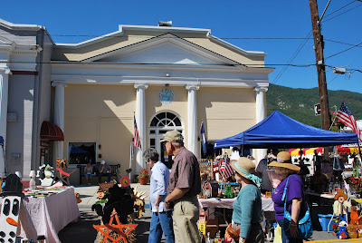
The Historic Roanoke City Market, also called the Farmer's Market due to the profusion of plants, fresh fruits, and vegetables available during the growing season, is the oldest continuously operating open air market in the Commonwealth of Virginia. It began when 25 licenses were issued to "Hucksters" (Vendors) in 1882.

The first City of Roanoke Charter formally authorized a municipally owned market in 1884. The first City Market Building was completed in 1886 and formed the core around which the Curb Market and Market Square developed. The original building was destroyed by fire and was replaced by the current building in 1922. After serving as an indoor market for many years, the City Market Building was renovated in the mid 1980's and currently houses an International Food Court - a hugely popular lunch time destination in downtown.

The Historic Roanoke City Market is open year-round, seven days a week, and closes only on Christmas and New Year's. There are 42 permanent tables covered by blue and white awnings that mark an inviting display of fresh fruits, vegetables, flowers, and plants during growing season. There are additional spaces in Market Square where vendors erect tents to display their wares. In recent years, a number of artisans have joined the farmers and planters offering handcrafted items, unique jewelry, and other art objects. The market even boasts a variety of fresh meats!

The Historic Roanoke City Market has been recognized as a "Great American Public Place" by the Lyndhurst Foundation along with other winners like the Vietnam Memorial in Washington, DC and Central Park in New York City. Locally, the market receives many "Best of Roanoke" awards by readers of the Roanoker Magazine.

Please check out That's My World where people from all over the globe share pictures of their part of the world.

07 December 2008

Today's Flowers-Morning Glories from My Garden

Morning Glories-October 2008
Each morning sees some task begin,
Each evening sees it close;
Something attempted
Something done,
Has earned a night's repose.
Henry Wadsworth Longfellow~

Take time to check out the link below for more photos from bloggers participating in Today's Flowers

01 December 2008

my world-the taubman museum of art-roanoke, virignia


The Taubman Museum of Modern Art opened November 8, 2008 to huge crowds. The 75,000 sf building was designed by architect Randall Stout. Among the attendees to the gala opening was Vice President Dick Cheney.

The Museum is named after Nicholas and Jenny Taubman who donated upwards of $25 million to the Museum's $66 million dollar project. They were the largest donor(s) to the project.

Nicholas Taubman is the former Chairman and Chief Executive Officer of Advance Auto Parts, the only Fortune 500 Company located in the Roanoke Valley. Mr. Taubman currently serves as U.S. Ambassador to Romania, a post he has held since 2005.

The building is interesting for a number of reasons. First and foremost it is plunked down in a small corner of historic downtown Roanoke. In fact, you can see in one of the photographs that it abuts an historic building. There is absolutely no potential for future expansion as a result of the "poor" site location. The building is located on a corner, on two sides it is adjacent to roads, the rear of the building is adjacent to the railroad tracks and the fourth side is adjacent to an historic building. Second, the building is "ulta" modern and stands out in a sea of brick and mortar structures. It looks like a fish out of water. And third, there is no parking near the Museum. I hope you enjoy the photographs. They were taken last week when I had a chance to get out and about. Roanoke is about 14 miles from where we live out in the rural outskirts of the Valley.

Please check out That's My World where people from all over the globe share pictures of their part of the world.

30 November 2008

a lovely peony from my garden

Yesterday we cleaned out the peony bed that had died back a month ago. I trimmed the stalks back to ground level. Adieu my beauties. Take time to check out the link below for more photos from bloggers participating in Today's Flowers

29 November 2008

REMINDER My Vintage Kitchen Towel Book and Vintage Textile Give-Away Ends Tuesday, December 2nd-Don't Forget to Enter!!!


Hello everyone.

Just a reminder that my blog give-away ends on Tuesday, December 2nd. If you haven't posted your most humorous holiday story yet, please do. Don't forget to leave me your email address so I can get in touch with you should you be the lucky winner~ I will announce the lucky winners on Wednesday.

I will be giving away a "new" autographed copy of my most recent book, "Colorful Vintage Tablecloths" and a Tom Lamb designed vintage kitchen towel to two, yes two lucky winners. The towel, pictured here, in unused and features the cutest anthropormorphic veggies marching to the soup pot.

So...why are you waiting, why not join in the fun, I know you will love my book.

24 November 2008

That's My World-Lake Moomaw, Virginia

Love the views at the Lake
Hooking the pontoon boat back up after a day on the lake

Marina Area at Lake Moomaw
Nestled in Virginia's scenic Allegheny Mountains, this area provides nearly year-round opportunities for boating, camping, fishing, hiking, horseback riding, hunting, mountain biking, picnicking, swimming, water sports, wildlife viewing and many other activities.

Lake Moomaw has been stocked with largemouth bass, smallmouth bass, brown trout, rainbow trout, lake run trout, brook trout, channel catfish, black crappie, yellow perch, chain pickerel, northern pike, gizzard shad, alewife, bluegill and various sunfish.

Gathright Dam and Lke Moomaw provide flood and water quality control along the Jackson and James Rivers in Western Virignia and are located on the Jackson River, 43 miles upstream from its confluence with the Cowpasture River, which, at that point forms the upper James River. The City of Covington is 19 miles downstream from the dam. From the dam, the lake extends 12 miles along the Jackson River. At its normal recreational level of 1,582 feet above sea level, the lake covers a surface area of 2,530 acres and has a shoreline of more than 43 miles.

Gathright Resevoir, as it was originally called, was authorized by Congress in the Flood Control Act of 1946. However, two years later in a similar piece of legislation, Congress stated that the project should be reviewed to determine the desirability of its construction. Lawmakers also questions whether some local funding should be sought based on benefits to be derived from water supply, pollution abatement and other conservation purposes.

In a review report to Congressional Public Works Committees, the Corps recommended that construction be undertaken without requiring local funding support. The project was put in abeyance in 1954, when it appeared that economic justification for Gathright was marginal. In 1957, it was officially "Deferred for Restudy."

The restudy, conducted in 1964, concluded that favorbale economic benefits would prevail by constructing Gathright Dam. Gathright was soon thereafter placed back on "Active" status, and initial construction was underway by 1967. A slowdown in Congressional funding minimized much of the construction work until 1970, when the project went into full gear. In 1978, following the death of Mr. Bejamin Moomaw, the man whose efforts brought the project into the Allegheny Highlands, Congress remanmed the area Gathright Dam, and Lake Moomaw. construction was comleted in 1981.

View Across the Road From My Friend's Acreage at Lake Moomaw-July 2008
A Cove at Lake Moomaw-July 2008
On the way to the main body of the lake, there are several little islands scattered about the lake and you can tie up your boat and have lunch on them or sun when the weather is right
Channel leading from boat dock to main body of the lake
July 2008
November 2008-Boat Dock
Water is let out from the lake area during the Fall and Winter to keep the river levels up downstream note difference between July photo immediately preceeding this one
(same vantage point)
November 2008-Boat Dock

The lake is 12 miles in length with a shoreline of 43.5 miles. The average depth is 80 feet and the depth at recreational pool intake tower is 150 feet. The surface area of the lake at normal water level is 2,530 acres. The spillway is 2,680 feet in length with a base width of 100 feet. It is an ugated spillway type.
July 2008 -Boat Dock
Dam and intake tower (located on left of photo)

The dam pictured above is 257 feet high, the length at top is 1,310 feet and the width at crest is 32 feet. The intake tower is multi-level and is 260 feet high. Above the dam at the entrance to the outlet tunnel is the 260-foot intake tower. Portals are arranged in the tower at nine levels in two wet wells. This allows the withdrawl of water from any level depending on the designed water temperature. Selective withdrawal of colder water from the lake, allows the Corps to maintain a prime trout habitat downstream from the dam. Hydraulically-operated sluice gates, eight feet wide and 17 1/2 feet high, used for flood control, are among the largest ever fabricated.

Through the south abutment of the dam there is a concrete-lined outlet tunnel, which is used for passing lake waters into a tilling or quieting basin before the water enters the Jackson River downstream.

Please check out That's My World where people from all over the globe share pictures of their part of the world.

17 November 2008

That's My World ... from Buchanan, Virginia

The Old Soda Fountain
Vintage Theater

Buchanan City Hall


Buchanan is located approximately 8 miles from my home. Each fall the town has the Mountain Magic in the Fall festival. The pictures are from this event taken back in October 2008. Please check out That's My World where people from all over the globe share pictures of their part of the world.

History of Buchanan

From its earliest development, the Town of Buchanan, Virginia was a principal crossing of the James River via the "Great Valley Road" and other regional transportation networks. As an early transportation-oriented community, the Town included taverns and ordinares, stables, blacksmith shops, wagon and carriage makers, general merchandise stores to service travelers, teamsters, and producers of goods being sent to external markets from the region.

Transportation routes and changes in modes of transportation have had primary influence on Buchanan's history. People settled in Buchanan because of the Town's location at a major intersection of transportation routes. Commercial and manufacturing enterprises located there because of the Town's advantageous location for transport of raw materials, goods and products. Changes in means of transportation shaped the Town's periods of growth in commerce and manufacturing.

Since the 1740's the area now encompassed by the Town of Buchanan has always been distinguished as the point of intersection between two principal transportation corridors: the great northeast-southwest overland route west of the Blue Ridge Mountains between Pennsylvania and the old Upland south; and the James River, the principal river system of central Virginia that provides and east-west route for transport of goods from Mountain and Valley Region, through the Piedmont, to the Tidewater and Chesapeake Bay.

In the 1740's the earliest trace of the Great Road from Philadelphia to western Virginia first crossed the James River at Looney's Ferry, whose approximate location is marked with an historic highway marker along route 11 west of downtown. Frontier colonial leader and land speculator James Patton obtained lands at the Great Valley Road crossing of the James River in the mid-1740's. His heirs the Buchanans, Boyds and Andersons acquired title to those lands and settled there over the next three decades. William Anderson laid out the town of Pattonsburg on the north side of the James River in 1788 while James Boyd laid out the Town of Buchanan on the south side of the James across from Pattonsburg in 1811. Plats of Buchanan in 1811 and Pattonsburg in 1818 established a grid of streets and enumerated lots that conform in large part with the current tax maps.

Water transport on the James River was improved from Buchanan to Tidewater by 1807 and the two towns became centers for processing agricultural products from southwestern Virginia for transport to Richmond and the Chesapeake. The Virginia General Assembly in 1819 acted to establish warehouses for inspection of tobacco and flour in both towns. River traffic increased in the 1830's with internal improvements that brought a better road system to Buchanan from western Virginia. By the mid-1830's internal improvements resulted in completion of the Cumberland Gap Turnpike from the Kentucky border to central Botetourt County.

By the 1840's Buchanan's buildings included the John Wilson warehouse, store and residence, the Botetourt Hotel and the Presbyterian and Episcopal churches, all brick structures which still stand today. By 1851 the James River and Kanawha Canal was completed from Richmond to Buchanan. At this time the two towns experienced a boom in commercial and artisan activity during the decade before the Civil War.

During the Civil War Buchanan served as an important Confederate supply depot for shipment of agricultural produce and pig iron to Richmond via the James River and Kanawha Canal. Federal General David Hunter marched through Pattonsburg and Buchanan on June 13, 1864 on his ill-fated raid of Lynchburg. After the Civil War commerce and manufacturing declined in Buchanan and Pattonsburg.

Numbers of town merchants and artisans fell sharply as canal traffic on the James River from Buchanan to Lynchburg was eclipsed by rail traffic from Salem to Lynchburg. Steel rail transportation came to the towns of Buchanan and Pattonsburg in the early 1880's, the time when Buchanan incorporated Pattonsburg into its Town limits.

Industrial growth and revival of commerce followed completion of the Norfolk and Western and the Chesapeake and Ohio lines through town because the new railroads hauled heavy freight to distant markets faster and at a lower cost than earlier wagons and canal boats.

The Continental Can Company and the Virginia Can Company established significant manufacturing operations in Buchanan after 1903. The Virginia Can Company employed at least 38 employees in 1906 and in 1910 owned buildings valued at $16,000 on a Norfolk and Western track siding just east of the original Town limits.

By 1920 railroad employees far outnumbered self-employed artisans. By World War I industrial manufacturing had replaced pre-Civil War patterns of production by skilled craftsmen. Industrial employment in Buchanan increased between 1920 and 1940 with limestone and bone product operations employing over 400 workers, many of whom commuted to town by automobile on newly improved hard surface roads.

On the eve of World War II, Buchanan's population had grown to 870 inhabitants and Land Books for the Town recorded 70 more lots with buildings than in 1910. Industrial employment continued to provide for Buchanan residents during and after World War II. Hafleigh and Co. converted to military production during the war and sold out to Groendyke Manufacturing Co. in 1965, an operation that by 1980 employed 125 workers in the manufacture of silicone and rubber products. The James River Limestone Company employed 125 workers in 1980. Buchanan's textile industry employed between 130 and 200 workers from the 1950's through the 1970's.

Since 1960 truck traffic on Interstate 81, the latest upgrade of the great overland route west of the Blue Ridge Mountains, shipped precut and finished garments to and from Buchanan.
Following recent annexations, Buchanan's population has grown to over 1,200 inhabitants.
Today, after decades of physical and economic decline, the Town of Buchanan has become a leader within the area for economic development within the context of Historic Preservation. This contemporary practice of development uses historic preservation as a catalyst for growth, promoting quality growth which respects the community's traditional land use development patterns.

After six years of concentrated downtown revitalization activities following the "Main Street Principles," and 3.5 million dollars of private sector investment, downtown has once again become host to a variety of businesses and residences proudly representing the community's dreams and aspirations.